
1617 Holland
By: Petrus Kerius
Date: 1617 (dated) Amsterdam
Dimensions: 15 x 20.25 inches (38 x 51.5 cm)
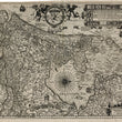
This landmark map of Holland first published by Petrus Kerius (also known as Pieter van den Keere) in 1617, offers a beautifully detailed representation of the Dutch province during the early 17th century. With French text on the verso, this example was likely published in Germania Inferior id est, XVII Provinciarum.
The map showcases the intricate geography of the region, with meticulous attention to the extensive network of waterways, towns, and agricultural lands that characterize the area. The cities and towns of Holland are prominently labeled, including Amsterdam, The Hague, Rotterdam, and Haarlem, emphasizing the economic and political significance of these urban centers.
Decorative elements enrich the map, including an ornate coat of arms flanked by allegorical figures at the top center and a compass rose with directional heading spelled out, and sailing ships, including a pair of boats hauling in fishing nets. The northern and eastern sections of the map include depictions of neighboring provinces and regions, reinforcing Holland's place within the larger Dutch Republic. The map also includes elaborate hatching to represent reclaimed land and polders, a hallmark of Dutch engineering and resilience against the sea.
Description of the Text Panel
The text panel at the top right of the map provides a detailed explanation of Holland's geographical and administrative features. The Latin and Dutch inscriptions highlight key aspects of the region, including its rivers, cities, and fortifications. The panel also discusses Holland's maritime prominence, referencing its harbors and the vital role of the Zuider Zee for trade and navigation. Surrounding the text are coats of arms for various towns and cities within Holland, further emphasizing the province's political and economic significance. The panel combines historical context with practical geographical information, serving as both a descriptive and decorative feature of the map.
Holland in the Early 17th Century
During the early 17th century, Holland was the economic and cultural heart of the Dutch Republic, which was emerging as a global maritime power. The province's wealth came from trade, shipbuilding, and agriculture, and its cities were thriving centers of commerce and innovation. Amsterdam had become a major hub for international trade, benefiting from the activities of the Dutch East India Company (VOC) and consequentially one of the richest cities in the world. Holland’s dense network of canals and waterways, evident on the map, was central to its success, enabling efficient transportation of goods and people.
This period also marked the Dutch Golden Age, a time of remarkable achievements in art, science, engineering and map making. The reclamation of land from the sea, depicted in detail on the map, symbolized the ingenuity and determination of the Dutch people. Kerius’s map reflects this prosperous era, blending precise cartography with artistic embellishments.
Condition: Map is in B+ condition presenting a heavy print impression on clean and sturdy paper. The top and left margins are narrow with some paper added to the top for framing. None of the original map image has been lost.
Inventory #12835
1200 W. 35th Street #425 Chicago, IL 60609 | P: (312) 496 - 3622


