


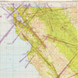
1946 / 1948 San Francisco - Sectional Aeronautical Chart
DESCRIPTION
This is a post-WWII era aeronautical chart of the California from the Channel Islands to San Francisco Bay, extending as far inland to include Fresno, Modesto, and Stockton showing important advancements in aviation communication technology, such as the use of VHF radio rages.
The map was published in the years following World War II, when civil aviation experienced significant growth and transformation. The wartime advancements in aircraft technology, navigation, and communication systems were adapted for commercial use. This map is an early example of wartime communication systems such as the Very High Frequency (VHF) which was a significant improvement for air traffic control and communication between aircraft and ground stations. These VHF ranges appear as purple rays extending from control centers.
About Aeronautical Maps
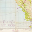
Aeronautical maps (also known as aviation charts or pilot maps), are specialized maps used by pilots for navigation during flight. They are comprised of many data layers that provide detailed information about airspace structure, navigational aids, airports, terrain features, obstructions, and other pertinent data crucial for safe flying. Over time, as populations have grown and technology has improved, these maps have become more complex. Older aviation maps such as this will likely appear very basic to any active pilot today.
CONDITION
1200 W. 35th Street #425 Chicago, IL 60609 | P: (312) 496 - 3622