Our Gallery is Open | Please Contact Us To Schedule Your Visit.

WWII Japanese War Map: Overview of Military Strength in the Pacic and Far East in Emergency Times By: Imamura Tsutomu, 1934 - Tokyo
WWII Japanese War Map: Overview of Military Strength in the Pacic and Far East in Emergency Times By: Imamura Tsutomu, 1934 - Tokyo | Japanese Translations
1934 Pre-WWII Japanese Naval Affairs War Map
Load image into Gallery viewer, WWII Japanese War Map: Overview of Military Strength in the Pacic and Far East in Emergency Times By: Imamura Tsutomu, 1934 - Tokyo
Load image into Gallery viewer, WWII Japanese War Map: Overview of Military Strength in the Pacic and Far East in Emergency Times By: Imamura Tsutomu, 1934 - Tokyo | Japanese Translations
Load image into Gallery viewer, 1934 Pre-WWII Japanese Naval Affairs War Map

1934 Pre-WWII Japanese Naval Affairs War Map

Regular price $ 700.00

Unit price per 

Overview of Military Strength in the Pacific and Far East in Emergency Times

By: Imamura Tsutomu

Date: Nov. 1934 (published) Tokyo

Dimensions: 20 x 29.5 inches (21 x 75 cm)

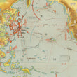
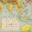
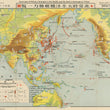
A fine example of a pre-WWII Japanese map showing in military forces in the Far East and Pacific theatre of war. The map created by Imamura Tsutomu and published in November, 1934 by the Tokyo based company Kaigun Graph as part of "Naval Affairs in The World."

From 1922 Japan along with the US, France, Italy and the UK signed the Washington Naval Treaty. This treaty limited the proliferation of naval power of the signing nations. Specially it gave a strength ration of 5:5:3 for UK, US and Japan. This was perceived as highly unfair by the Japanese. After Japan's withdrawal from the League of Nations in 1933, a Japanese delegation was sent to London demanding naval parity with the United States. This was rejected as the Japanese delegation assumed it would be. Finally in December of 1934, a month after the publication of this map, Japan formally withdrew from the Washington Naval Treaty.

This map offers a snapshot moments before the breakdown of the interwar Washington Treaty system, and the rise of Japanese naval power. It would have been widely known and talked about in Japanese as well as international media. Japan would undertake rapid expansion of its naval fleet not long after this map was published; soon after the naval powers treaty was abrogated Japan began planning such projects as the construction of the Yamato and Musashi, two of the heaviest battleships ever constructed.

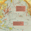
NOTE: As a reference, we have included two images with translations that are not part of the original map.

Condition: This map is in B+ condition with fold separations that have been professionally reinforced on the verso. Some soiling along a few creases as well as light offsetting from red ink is apparent. 

Inventory #12139

1200 W. 35th Street #425 Chicago, IL 60609 | P: (312) 496 - 3622

Close (esc)

Join Our Newsletter

Interested in maps, prints, and upcoming related events? Sign up for our newsletter for fresh NWC inventory and announcements.

Age verification

By clicking enter you are verifying that you are old enough to consume alcohol.

Search

Shopping Cart

Your cart is currently empty.
Shop now