


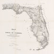
1856 Map of the State of Florida
DESCRIPTION
The earliest land survey map for the entire state of Florida, conducted by the U.S. Government in the years between Second and Third Seminole War.
This official 1856 map of Florida was produced to accompany the Annual Report of the Surveyor General, documenting the progress of federal land surveys across the state. Published under the authority of the General Land Office and approved by Commissioner J.A. Hendricks, the map presents Florida in the context of mid-19th century expansion, emphasizing surveyed townships, key settlements, natural features, and transportation routes. It was issued as Senate Executive Document No. 5, 2nd Session, 34th Congress, providing Congress and federal administrators a visual report of land distribution and usable acreage in Florida’s developing landscape.
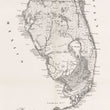
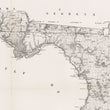
The map delineates Florida’s borders with Alabama and Georgia and includes detailed coastal outlines along both the Gulf of Mexico and Atlantic Ocean. Notable features include Lake Okeechobee, labeled as “Lake Macaco,” the Everglades depicted with swamp topography, and the Florida Keys strung out along the southern tip. Numerous rivers such as the St. Johns, Suwannee, and Apalachicola are visible, along with internal lakes, wetlands, prairies, and drainage patterns that defined the state’s hydrology and limited arable land. Townships and sections are clearly demarcated using the Public Land Survey System, which had been extended into Florida as part of U.S. efforts to formally divide and sell federal lands.
Settlements and Infrastructure
The map identifies towns, forts, and transportation routes critical to Florida's 19th-century development. Many of these, such as Tampa, St. Augustine, and Key West, served as military outposts or port cities vital to trade and governance. Roads and trails link isolated interior regions to the coasts, although much of the southern peninsula remains sparsely settled, with the Everglades and Big Cypress Swamp largely unsurveyed and uninhabitable by European settlers. Several forts are marked across the state, reflecting ongoing federal military activity during this period.
The State of Florida in 1856
By 1856, Florida had been a state for just over a decade, admitted to the Union in 1845. The land survey reflected federal ambitions to populate and exploit Florida’s terrain, despite its challenging environment. This period followed the conclusion of the Second Seminole War (1835–1842), though hostilities continued with the Seminole people in what would become the Third Seminole War (1855–1858). Many of the mapped military posts and routes were strategically positioned to aid in the removal of Native populations and to protect settlers. Settlement and agricultural development were concentrated in the north and along the coasts, as large parts of central and southern Florida remained wild and difficult to navigate.
This map captures a moment in Florida’s early statehood where federal land policy, military presence, and environmental realities intersected. It offers a valuable record of how the U.S. government sought to tame and organize a frontier state through systematic surveying and the imposition of grid-based land division. As one of the earliest complete survey maps of the state, it is an important artifact in understanding both Florida’s geography and its turbulent journey into American expansionism.
CONDITION
1200 W. 35th Street #425 Chicago, IL 60609 | P: (312) 496 - 3622