


1821 Carte Generale dela Turquie d’Europe a la droite du Danube…
DESCRIPTION
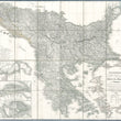
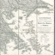
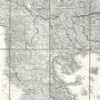
Carte generale de la Turquie d'Europe a la droite du Danube ou des beglerbegliks de Roum Ili, Bosna et Moree
By: Frédéric Guillaume de Vaudoncourt
Date: 1821 (published)
Dimensions: 33.75 x 37.5 inches (85.75 x 95.25 cm)
This magnificent large folding map with linen backing depicts those regions of Europe which, at the time of the map’s publication, were either under Ottoman rule or had recently seceded from it. Internecine strife had taken its toll on the Ottoman Empire more than two centuries before the map was published, and actual control of territories defined as part of the Empire was divided among the most powerful local potentates, ranging from governors and pashas to religious leaders and even mayors of major municipalities.
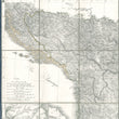
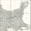
The European territory depicted includes the Balkan Peninsula in great detail, along with regions to the north and west of it and the Greek islands, and extends eastward to the Danube Estuary on the Black Sea. The Danube serves as the northern border of Ottoman European dominion at the time the map was drawn. To the east and south it includes western Anatolia as far to the east as the island of Rhodos. This section of the map features primarily the coastal cities and ports of the Empire with no details in the interior.
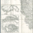
Three inset maps are featured in the lower left of the map, including the city and environs of Constantinople, while another is of the channel of the Dardanelles. Interestingly, the third depicts the environs of ancient Thermopylae - site of the historical battle with the Spartan led Greek forces against the Persian invaders there in 480 BCE. No doubt it is featured due to the Greeks attempting to hold a defensive position in the historically-charged site in 1821 in the early stages of the Greek War of Independence against the Ottoman Empire.
The map is known to have been published as early as 1818, just as Greece was beginning to solidate its forces, which would ultimately result in independence in 1829. The Greek War for Independence began in 1821 with the invasion of the Danubian principalities organized primarily by Alexandros Ypsilantis. It ended in 1829 with the signing of the Treaty of Adrianople which saw the Ottomans granting autonomy to Greece. The map shows the serious territorial losses experienced by the Ottoman Empire following its zenith in the mid sixteenth century.
The territory covered reveals a swathe of Europe much diminished in size, depicting the extent of the Ottoman Empire following nearly two hundred years of decline from its zenith under the remarkable Emperor Süleyman I (known as the Magnificent), who ruled from 1520-1566. Under his rule the empire stretched from the gates of Vienna, Hungary, through all of Greece and its islands, the Crimea and northward towards the Don River. It also included all of Anatolia and as far east as Mesopotamia, including Basra and parts of the Arabian Peninsula. The entire Levant, Egypt and a strip of northern Africa reaching almost to Gibraltar were also under Ottoman dominion.
Thus this map depicting the extent of the Empire in the early nineteenth century in Europe, also reveals the significant territorial decline of the Ottoman Empire by that time. Within another century, the Ottoman Empire, which had been one of the largest and longest ruling empires in the world, would become the Turkish Republic, headed by Mustafa Kemal Atatürk.
Condition: This large folding map is in A condition offering a vivid print on clean paper. Linen is sturdy and with tears along the folds making is suitable for framing or study. The map is presented in a marbled folding cover which fits inside a red, fabric-covered sleeve on which is embossed the name of the map and its cartographer. Both are in very good to fine condition.
Inventory #12692
1200 W. 35th Street #425 Chicago, IL 60609 | P: (312) 496 - 3622
CONDITION
1200 W. 35th Street #425 Chicago, IL 60609 | P: (312) 496 - 3622