
Cologne, Germany circa 1572 from Civitates Orbis Terrarum
George Braun was born in Cologne and lived his entire life in the great city on the Rhine, dying there in 1622. He obtained his education in his home city, and by 1561 had completed the equivalent of a bachelor’s degree, and in 1562 completed his Magister Artium, or Master of Arts. On completing his studies, he entered the Jesuit Order of Cologne as a novice. He eventually left the Order but studied theology and spent much of his adult life as canon and dean of St. Maria ad Gradus, a Catholic church in Cologne which was located near the Cologne cathedral. In addition to his church duties, he was also a writer, publisher and editor whose best known work is Civitates Orbis Terrarum, or Cities of the World, which was the first known such atlas, and which was published in his home city.
From 1572 to 1617 Braun worked on and edited the Civitates, which contains 546 prospects, bird's-eye views and maps of cities from around the globe, along with extensive and highly detailed text. This work was undertaken following the publication of the Theatrum Orbis Terrarum, or Theater of the World, the first world atlas, by Abraham Ortelius in Antwerp in 1570.
Antwerp from Civitates Orbis Terrarum
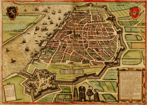
Antwerp circa 1572 from Civitates Orbis Terrarum
The Theatrum was very well-received, and Braun, working together with Ortelius and Franz Hogenberg, conceived the idea of an atlas of cities. Much credit is given to Braun in the organizing of the work on the Civitates, including the finding and hiring of over one hundred artists and topographers, and doing most of the writing of the texts which accompany each map, in itself an enormous accomplishment. He is also credited with having done virtually all the editing of the work. Ortelius obviously had much to do with the organization of the atlas itself, as it strongly resembles that of the Theatrum. Franz Hogenberg is known to have done virtually all the engraving of the maps and other images. Braun wrote the prefaces for all but the sixth part, intimating at the breadth and depth of his social connections throughout all of Europe and even beyond. He lived to his eighties and was the only member of the original group of three to live to see the publication of the sixth volume of Civitates, in 1617.
The completed work contains six title pages for each of its six parts, and 363 engraved plates. Civitates Orbis Terrarum had no precedent, and was immediately popular due in part to the increase in travel in Europe in the 16th century. Being the principle centers of social, cultural, political and economic life, cities were popular destinations. The publication of the Atlas of Cities provided travelers an idea of what they would encounter, and armchair tourists a glimpse of exotic places they would only visit in the pages of Civitates Orbis Terrarum. It is one of the most important works of early cartography and topographical illustration in Europe and is the first systematic depiction of views of cities throughout the world in the late 16th and early 17th centuries, and Braun’s contributions to it cannot be overstated. A visit to Constantinople in the 16th century was impossible for all but a very few European statesmen and merchants, or an armchair tourist viewing it in his Civitates.

Constantinople circa 1572 from Civitates Orbis Terrarum