Mesopotamia, named in Greek for the region situated between the two rivers Tigris and Euphrates, gave birth to some of the earliest known settlements when isolated groups of hunters and gatherers began merging, forming larger communities of permanent habitation. Civilization quickly evolved in the Fertile Crescent as these agricultural societies developed.

Due to lack of easily accessible stone, structures in this area were built of mud bricks, and baked clay in the form of tablets was used for keeping records. Over the years, countless of these clay tablets have been found, providing encyclopedic information about the development of early civilization in that area.
These tablets reveal that the creators of this civilization were keen to record various kinds of information, including boundaries of plots of land and fields. Some of the oldest extant maps have been found on stone boundary markers demarcating early divisions of land. Irrigation canals were built which provided water for crops and everyday life, and tablets survive depicting these systems.
The Oldest Known World Map
A Babylonian map called Imago Mundi, commonly referred to as the oldest known world map, was found in 1881 by Iraqi Assyriologist Hormuzd Rassam just north of the ancient city of Babylon on the east bank of the Euphrates River. Inscribed on a clay tablet, it has been dated to somewhere between the sixth and ninth century BCE. By the time he came across the tablet, Rassam had a distinguished career in archaeology. For a number of years he had been an assistant to the famed British Assyriologist Austen Henry Layard, and played a key role in Layard’s excavations at Nimrud . When Layard left the field to enter politics, Rassam undertook studies at Oxford, following which he was retained by the British Museum to lead ongoing excavations at Nimrud, Nineveh, and other important sites of the Fertile Crescent.
Rassam was excavating on the east bank of the Euphrates near the ancient city of Sippar, searching for evidence of the great Flood described in the Old Testament when he found a clay tablet inscribed with cuneiform writing. He was unable to read its cuneiform text, and ascribed little importance to it. Nevertheless, the tablet found its way to the British Museum where, in the late 20th century, scholars at the Museum deciphered its text and realized its importance.
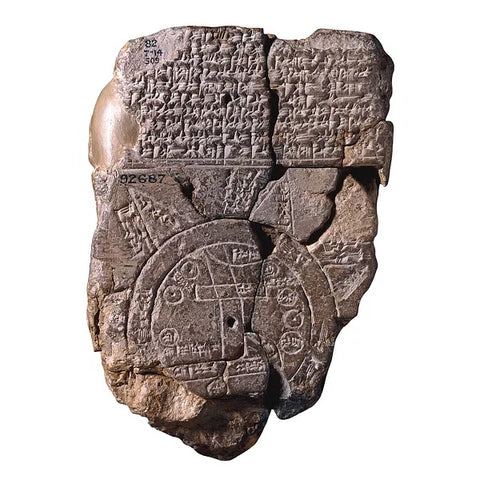
The map is regarded by many scholars to be as significant as the Rosetta Stone at the British Museum, and the Code of the great king of Babylon, Hammurabi, at the Istanbul Archaeological Museum. While the tablet does indeed contain a map, the map is not of the world in its entirety, rather it is the world known to the Babylonians of the era in which it was produced. It depicts a flat world in which Babylon is surrounded by seven islands and seven cities, all surrounded by what resembles a moat, and the waters are labeled in cuneiform as ‘Salt Sea’ and ‘River of Bitter Water’. Four surviving triangles of which it is thought were originally eight are affixed to the edge of this moat-like ring. This modern day interpretation of the map was rendered in 1929 by German Assyriologist Bruno Meissner.

The triangles are thought to represent regions more distant from Babylon. Assyria, Elam and other places are named. Other specific topographical features include the Euphrates River which runs from north to south through the middle of the map, a canal, a swampy area, mountains, including the Zagros range, and a number of important regional cities, some named with others represented but unnamed. The cities and regions denoted are relatively close to their actual geographical positions.
Explanatory cuneiform text covers approximately one third of the front of the map and the verso is entirely covered with descriptive text. The text above the map has been translated as a Babylonian description of the creation of the world. Text on the verso describes various components of the map. Information in the cuneiform text which accompanies the map suggests that it is a copy of an older map, lending credence to the idea that long before mankind developed written language, maps were being made.