


1863 Johnson's California, Territories of New Mexico, Arizona, Colorado, Nevada and Utah
By: Johnson and Ward
Date: 1862 (published) New York
Dimensions: 17.5 x 25 inches (44.5 x 63.5 cm)
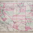
This is an original antique map of the Southwestern United States shown as territories with the exception of California, published by Johnson and Ward out of New York in 1863. The map is color coded by county and shows land, lakes, rivers, railroads, towns, military forts and the locations of numerous Native American Tribes.
This map is one of several maps of the American West where the boundaries and configuration of territories changed almost yearly. Much of the geography of the western territories is still unknown and it shows in the map as large swaths of land are depicted featureless including the area of the Grand Canyon. In all capital letters reads the names of nearly twenty Native American tribes some of which include, the Cheyenne, Navajo, Yampais, Apaches, and Mojaves to name a few. Numerous military forts and frontier outposts offer contrast in the map to the native population as a historical documentation of the struggle over the west.
Last but not least, Routes of explorers and military commanders such a Fremont, Gunnison, and Kearny can be traced as well as the short lived yet legendary Pony Express Mail Route which ran from Sacramento to eastern Kansas and operated from April 3, 1860, to October 26, 1861. The addition of gold and silver mines, mountain peaks with the height of their summit and notations on land topography and the availability of (or lack their of) water and timber complete all encompassing view of the American West, making this map a "must have" for anyone with in interest in its history.
Condition: This map is in A condition with bold original color on fine paper with ample margins on all sides. Some light staining is apparent along the centerfold and at either end of the side margins, but does not distract from the map image.
Inventory #NA151-2
1200 W. 35th Street #425 Chicago, IL 60609 | P: (312) 496 - 3622