


1630 America Meridionalis
By: Mercator / Hondius
Date: 1633 (published) Amsterdam
Dimensions: 14 x 19 inches (35.5 x 48.25 cm)
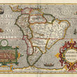
This stunning map of South America, one of the earliest obtainable maps to feature the continent on its own, was first published separately by Gerard Mercator in 1569. In this map, South America retains the bulge of its eastern portion as Mercator had depicted it in his earlier world map of 1538. It differs from that map in that the continent is elongated and more closely resembles its true geographic form.
The entire eastern portion of the continent is rendered almost as an island, with the Rio de la Plata River running from the northwestern edge of it to the southwestern. The Amazon is rendered as part of a river system running east and west which forms a tributary to the Rio de la Plata system. Many of the regions already bear the names by which their respective countries are known today. Around the entire continent is an uninterrupted series of toponyms naming settlements, ports, rivers, capes and bays. The interior depicts extensive river systems, lakes, and mountain chains. The Straits of Magellan are shown, but Tierra Del Fuego is shown as part of the large southern continent.
An indigenous giant rumored to inhabit Patagonia strides with bow and arrow in the southern part of the continent. Fictitious lakes including "Parime Lacus," within Guiana that was rumored to be filled with gold dust is also shown and would appear in maps for the remainder of the 17th century. A beautiful inset in the lower left quadrant features the Incan capital city of Cusco, Peru, with a group of locals depicted, escorting their ruler toward a city gate in a palanquin.
The map is further embellished with fanciful monsters, ships at full sail and a mysterious vignette featuring an indigenous boat in which two adults, one holding an infant, observe a fire in the center of said vessel. The title cartouche is done in an elaborate strapwork style. French text on the verso provides much detail about the continent and its inhabitants, its flora and fauna.
Condition: Map is in A condition with lovely color over a strong impression on clean paper with full margins.
Inventory #11596
1200 W. 35th Street #425 Chicago, IL 60609 | P: (312) 496 - 3622