

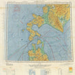

1944 Army Air Force Chart: Hakodate, Japan (Escape & Evasion Cloth Map)
By: U.S. Army Air Forces
Date: 1944 (dated) Washington D.C.
Dimensions: 24 x 20.5 inches (61 x 52 cm)
This is an authentic cloth map northern Japan, produced for pilots in the United States Air Force during WWII. The map centers over the strait between Honshu and Hokkaido on one side and part of the eastern coast of Hokkaido on the other side. Originally produced in 1942, a second edition was made in 1943. The side with the two islands is the 1943 second edition and the other side is a revised 2nd edition made in 1944.
The specific time period of this map is important with regards to the area it shows. Between the months of July and August of 1945 several carrier plane strikes were made by the United States on Noheji (Honshu), Muroran (Hokkaido), and Kushiro (Hokkaido), as well as surface bombardments along the coast of Muroran (Hokkaido). All of these places are within or near the area shown in this map.
Escape and Evasion Maps
During WWII, escape and evasion maps were produced for United States, British, and other allied service members as a means to find their way to safety when stranded behind enemy lines. Since durability was of the utmost priority (along with geographic accuracy) these maps were printed on cloth. This way the map would not tear or dissolve if it were to ever come into contact with water, a distinct likelihood for American pilots serving in the Pacific theatre of war.
This particular map included topographical information, direction and consistency of water and air currents, locations towns with various symbols based on their population, delineates minor and major roads, railways, submarine cables, radio stations, lighthouses, and includes a glossary of useful words translated into Japanese. Such words include kawa meaning river, shima meaning island, zaki meaning cape or point, and zan meaning mountain. These maps proved to be extremely useful to any soldier that found themselves behind enemy lines and no doubt save many lives.
Condition: This WWII cloth map is in B+ condition with no stains but some light soiling. One edge has begun to fray, but should not continue if kept in proper care. Most of the creases have been ironed out, though some still remain.
Inventory #11993
1200 W. 35th Street #425 Chicago, IL 60609 | P: (312) 496 - 3622