

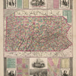
1855 Pictorial Map of Pennsylvania
By: Ensign, Bridgman & Fanning
Date: 1855 (dated) New York
Dimensions: 34 x 26 inches (86.5 x 66 cm)
This scarce map of Pennsylvania presents a detailed and visually rich depiction of the state, combining precise cartography with historical context. Published by Ensign, Bridgman & Fanning in the mid-19th century, it features hand-colored counties, labeled towns, railroads, and natural features, providing a comprehensive view of Pennsylvania’s geography. The ornate border and decorative elements enhance its visual appeal, making it both an informative and artistic representation of the state.
The map includes portraits of William Penn and Benjamin Franklin, two figures central to Pennsylvania’s early history and development. A vignette of Independence Hall in Philadelphia highlights its role as a cornerstone of American democracy, while an illustration of Washington Crossing the Delaware commemorates a pivotal Revolutionary War moment. These historical references emphasize Pennsylvania’s significance in shaping the United States.
Inset maps of Philadelphia and Pittsburgh provide a closer look at the state’s most influential urban centers during the 19th century, reflecting their industrial growth and strategic importance. A population chart in the upper right corner presents demographic data, offering insight into Pennsylvania’s expansion and economic standing at the time. The inclusion of statistical information alongside cartographic details underscores the map’s dual purpose as both a reference and historical document.
Intricate border designs, historical vignettes, and fine engraving techniques contribute to the map’s elaborate presentation. It features illustrations of Independence Hall, Washington crossing the Delaware River, and portraits of Robert Morris and Benjamin Rush. Additional illustrations at top include the state emblem and portraits of William Penn and Ben Franklin. The combination of geographic accuracy and artistic embellishments captures Pennsylvania’s historical, economic, and cultural development, while showcasing the craftsmanship of 19th-century mapmakers.
Condition: Map is in B+ condition with several short marginal tears that have been repaired on the verso. Some darkening of the paper is apparent, but the overall color and eye appeal is exceptional.
Inventory #12878
1200 W. 35th Street #425 Chicago, IL 60609 | P: (312) 496 - 3622