


1930 Provincial Maps of Japan (8)
DESCRIPTION
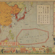
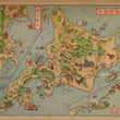
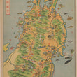
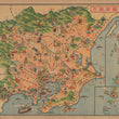
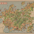
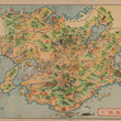
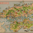
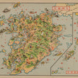
This beautiful collection of 8 provincial maps is in a splendid and unique cartoon or pictorial style emblematic of early 20th century Japanese map making.
During the era in which this booklet was published Japan was experiencing a wave of fervent nationalism. The fascist Kokumin Domei was ascendant around this time, opening the way for strong military intervention on all affairs political. In this collection of pictorial maps one can see the Japanese conquest of South Korea and the possession of the southern border of Sakhalin. Both of these territories were spoils from the Russia-Sino war of 1904-05, which was the victory that catapulted Japan onto the world stage.
Lining the margins of the first page, and within the other 7 maps one can see the playful yet detailed cartoon imagery of people living and working on the islands. Prominent on every map is at least one or two military figures. Japanese Zero fighters, geisha, and samurai make their appearances as well, cementing the traditional Japanese values that were so loved at the time.
CONDITION
1200 W. 35th Street #425 Chicago, IL 60609 | P: (312) 496 - 3622