


1838 CARTE DES ÉTATS-UNIS D'Amérique, du Canada, du Nouveau Brunswick et d'une partie de la Nouvelle-Bretagne
DESCRIPTION
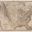
This antique map of the United States, Canada, and surrounding territories by Lapie is a compelling representation of a continent in the midst of major transition. It captures the political independence of Texas, the emerging statehood of Michigan, the ambiguous claims in the Pacific Northwest, and the mythical geography of the western frontier. Additionally, it preserves a record of indigenous nations at a time when their presence was still deeply interwoven with the fabric of North America.
Four Courties Shown in the Map: New Britain, United States, Mexico, & Texas
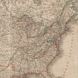
The map stretches from coast to coast of the United States with large portions of New Britain (Canada) and Mexico prior to the Mexican-American War but after the Texas Revolution. Published in 1838, the map captures the Republic of Texas (outlibned in yellow) at a time when Mexico still refuted its soverignty. The border depicted on this map is actually smaller than present-day Texas, as it does not extend as far south as the Rio Grande ( Rio Brabo ) and there is no panhandle.
False Rivers and Uncertain Cartography of the Southwest
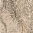
The western portion of the map dominated by Mexico (present-day California, Arizona, New Mexico, and Utah), displays numerous incorrect and mythical river systems. The Río Buenaventura, a completely fictional river, is depicted flowing westward from the Rocky Mountains to the Pacific. This mistaken belief persisted in maps well into the 19th century. The Rio Colorado ends without an outlet in a large blank space on the map. It of course drains into the Gulf of California which is omitted entirely from the map to make room for the title cartouche.
The Disputed 49th Parallel in the Pacific Northwest
A notable cartographic feature of this map is the extension of the U.S. border north of the 49th parallel, particularly in what is now British Columbia. This suggests uncertainty or an alternative interpretation of the Oregon boundary dispute, which would not be formally settled until the Oregon Treaty of 1846, establishing the present-day U.S.-Canada border at the 49th parallel. Prior to the treaty, both Britain and the United States laid claim to portions of the Pacific Northwest, and maps such as this one reflected competing territorial ambitions.
Territories of Michigan, the Northwest, Missouri, and Arkansas
The Michigan Territory, which had only recently achieved statehood in 1837, is still partially labeled as a territory, reflecting lingering disputes over borders. To the west, the Northwest Territory encompasses what would later become Wisconsin, Minnesota, and parts of the Dakotas. At the time, these regions were still sparsely populated, with European-American settlements concentrated around the Great Lakes and along key river routes.
The Missouri Territory, established after the Louisiana Purchase, is shown encompassing much of the central United States, stretching westward beyond the Mississippi River. Though Missouri had become a state in 1821, large swaths of unorganized land still bore the territorial designation. The Arkansas Territory, depicted south of Missouri, reflects its status prior to Arkansas achieving statehood in 1836. The region is largely rural and unsettled, with scattered forts and indigenous nations populating the landscape.
Mapping Native American and Indigenous Presence
This map is rich in its depiction of Native American tribes, marking the homelands of numerous indigenous nations, including the Sioux, Cheyenne, Comanche, Apache, and many others. Many of these groups played pivotal roles in shaping the westward expansion of the United States, engaging in trade, diplomacy, and resistance to encroachment on their lands. The inclusion of these tribes emphasizes their recognized presence and influence before the full-scale settlement and displacement that would intensify in the coming decades.
CONDITION
1200 W. 35th Street #425 Chicago, IL 60609 | P: (312) 496 - 3622