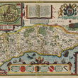

1610 Sussex Described and divided into Rapes
DESCRIPTION
This is a most regal map the English county of Sussex, by Jodocus Hondius divided into its traditional administrative divisions, known as “rapes.” While engraved by Jodocus Hondius, the map first appeared in John Speed's atlas "The Theatre of the Empire of Great Britain."
The map includes a large inset of Chichester, the county's principal city, showing its layout with streets, buildings, and fortifications clearly rendered. It features rivers, towns, villages, and hills, all depicted in an artistic manner typical of the early 17th century. The map is adorned with coats of arms belonging to nobles who held the title of Earl of Sussex since the Norman Conquest, underscoring the historical significance of Sussex as a prominent region in England’s aristocratic and political landscape. The title cartouche is elaborately decorated, flanked by classical figures, and a lion and unicorn crest at the top symbolize royal authority.
Additionally, there are depictions of ships at war in the English Channel, indicating the importance of Sussex’s coastal position along the British Sea for trade and defense. The map is further embellished with sea monsters, scenes of warfare, and an accompanying narrative panel that describes the history of the region beginning with William the Bastard, Duke of Normandy making his claim to the Crown of England...
Sussex in the Early 17th Century
In the early 17th century, Sussex was a region of significant economic, strategic, and historical importance. The county, located along the southern coast of England, played a vital role in maritime activities, including fishing, trade, and defense against potential invasions. Chichester, depicted in the map's inset, was a historic Roman town that served as a central hub of administration and commerce. The map highlights Sussex’s division into rapes, which were unique to this county and served as administrative divisions centered on fortified castles.
The period during which this map was created was marked by relative stability under the reign of King James I. However, Sussex retained its strategic importance, particularly due to its proximity to continental Europe. The coastline was dotted with ports and harbors that connected England to the trade routes of the Channel and beyond. Inland, Sussex was characterized by its fertile farmland, dense forests, and historical sites, which are subtly suggested in the map’s depiction of the terrain.
The Map Verso
The verso of this map provides a detailed description of Sussex, focusing on its historical, administrative, and geographical characteristics. The content is divided into sections, with one part listing the hundreds and rapes (administrative divisions) of Sussex, along with the towns and villages that fall under each jurisdiction. This listing provides a comprehensive catalog of settlements, reflecting the organizational structure of the county in the early modern period.
Another section provides a narrative description of Sussex, discussing its geography, economic resources, and historical significance. The text highlights Sussex's location along the southern coast of England and its role in maritime trade and defense. It describes the natural resources of the region, including its forests, fertile lands, and waterways, which supported agriculture, industry, and transportation. Historical events and notable features, such as Chichester’s prominence and religious sites, are also referenced.
CONDITION
1200 W. 35th Street #425 Chicago, IL 60609 | P: (312) 496 - 3622


