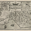

1611 Glamorgan Shyre, With the Situations of the Cheife Towne Cardyffe and Ancient Landaffe Described
DESCRIPTION
This is a superb, original, uncolored example of map of Glamorgan Shyre that appeared in the first edition of John Speed’s "The Theatre of the Empire of Great Britaine," published from 1611 to1612. It is identified as such by the note a lower right siting the sale against the exchange by John Sudbury and George Humbell.
The map provides a detailed depiction of Glamorgan, a historic county in southern Wales, emphasizing both its geographic and administrative features. It is meticulously illustrated, showing rivers, towns, villages, and mountainous terrain, as well as Glamorgan’s coastline along the Bristol Channel. Administrative divisions are marked, reflecting the hundreds (subdivisions) that structured the governance of the county at the time.
The decorative elements are characteristic of Speed’s work (and his contemporaries), featuring two inset maps: one of Cardiff, the chief town of Glamorgan, and the other of Llandaff, an ancient ecclesiastical site. The inset of Cardiff highlights the town’s streets, fortifications, and prominent buildings, while Llandaff’s depiction focuses on the cathedral and surrounding structures, emphasizing its historical and religious significance. The map is further adorned with elaborate cartouches, compass roses, and depictions of ships and sea creatures, evoking the maritime importance of the county.
Glamorgan in the Early 17th Century
During the early 17th century, Glamorgan was an important county in southern Wales, known for its fertile lands, historical significance, and strategic location along the Bristol Channel. Cardiff, as the county's administrative and economic hub, was a bustling town with connections to both England and other parts of Wales. Llandaff, on the other hand, served as a key religious center, with its cathedral being one of the most notable ecclesiastical structures in Wales.
Glamorgan was also characterized by its varied terrain, from the mountainous regions in the north to the fertile valleys and coastal plains in the south. Agriculture and trade, facilitated by the county’s access to the Bristol Channel, were central to the economy. The map reflects this diversity, with careful attention to the depiction of both the physical geography and the settlements that dotted the landscape.
Description of the Verso
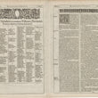
The verso provides a detailed written account of Glamorgan, including its history, geography, and notable features. It is divided into sections, with one part presenting a comprehensive alphabetical table of the towns, villages, rivers, and landmarks within the county. This catalog serves as a practical reference for readers, highlighting the organizational structure of Glamorgan.
The narrative section elaborates on the county’s historical and cultural significance, describing its role within the broader framework of Wales and England. It references key sites such as Cardiff and Llandaff, providing insight into their importance in both secular and religious contexts. Together, the map and verso offer a rich visual and textual representation of Glamorgan in the early modern period, combining cartographic precision with historical and cultural context.
CONDITION
1200 W. 35th Street #425 Chicago, IL 60609 | P: (312) 496 - 3622


