


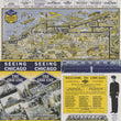
1950s The Gray Line Seeing Chicago Pictorial Map
DESCRIPTION
Cleverly hidden in the brochure for The Gray Line's Seeing Chicago tour is this colorful, playful pictorial map of Chicago. With cartooned vignettes depicting neighborhoods and locals around the city from an aerial view.
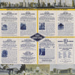
The metropolitan black and yellow checkered border ensconces the map which spans Jackson Park north to Evanston with Northwestern University appearing in a circular inset. The verso features a wide array of Gray Line tour itineraries with prices as well as artist renderings of the Chicago skyline, the Museum of Science and Industry, Buckingham Fountain, and the Field Museum.
CONDITION
Map is in very fine condition with original folds and slight toning and minor losses to the edges. Full margins with light bumps at corners.
1200 W. 35th Street #425 Chicago, IL 60609 | P: (312) 496 - 3622