


1972 Experimental Skylab Mission Chart (SMC)
DESCRIPTION
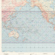
This is a rare orbital space flight chart published for the National Aeronautics and Space Administration (NASA), showing the ground track for the first 71 revolutions in Earth's orbit of the first experimental Skylab Mission.
Officially launched with a three man crew in May of 1973, Skylab was coined the first scientific laboratory beyond Earth and would remain in continual operation until 1979. Skylab was designed to study the effects of long-term spaceflight on the human body and to conduct various scientific and technological experiments in microgravity. It hosted three astronaut crews who lived and worked on the station for extended periods, with the longest mission lasting about 84 days. Skylab would served as a crucial step in advancing human spaceflight capabilities and setting the stage for future space stations, such as the International Space Station.
In the lower left corner, we find the wording "1st Experimental Edition May 23, 1972" and in the top right, we find a manuscript annotation which reads "Launch 1330 EDT - 14 May 1973." Additionally, there are several "x" markings in pencil along the southern portion of the map that are just off the ground track lines. All things considered, we believe this map to be a hypothesized track of the Skylab based on NASA calculations.
CONDITION
1200 W. 35th Street #425 Chicago, IL 60609 | P: (312) 496 - 3622