


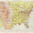
1956 United States: Aeronautical Planning Chart - U.S. Air Force Edition
DESCRIPTION
A mid-century U.S. Air Force map of the continental United States including parts of Mexico and Canada, published just 10 years after the establishment of the United States Air Force, created under the National Security Act of 1947.
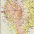
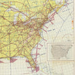
This aeronautical map of the United States is colored by elevation, divided into Air Defense Identification Zones (ADIZ), and lined with controlled and uncontrolled civil airways. Aerodromes with land and water facilities are identified throughout the map with their elevation and length of longest runway (in hundreds of feet) noted. Larger cities and areas with military bases typically have an air traffic control center and are identified as such with a red rectangle surrounding the name. This particular map includes annotations in blue pen and in pencil within the southwest region of Arizona and New Mexico
The United States Air Force (USAF) was established as a separate branch of the U.S. military on September 18, 1947, following the enactment of the National Security Act of 1947. This act was signed by President Harry S. Truman and reorganized the military and intelligence services after World War II. Prior to its establishment as an independent service, air operations were conducted under the U.S. Army Air Forces (USAAF). The creation of the USAF marked the recognition of the strategic importance of air power and the need for a distinct service branch dedicated to air and space operations.
About Aeronautical Maps
Aeronautical maps (also known as aviation charts or pilot maps), are specialized maps used by pilots for navigation during flight. They are comprised of many data layers that provide detailed information about airspace structure, navigational aids, airports, terrain features, obstructions, and other pertinent data crucial for safe flying. Over time, as populations have grown and technology has improved, these maps have become more complex. Older aviation maps such as this will likely appear very basic to any active pilot today.
CONDITION
1200 W. 35th Street #425 Chicago, IL 60609 | P: (312) 496 - 3622