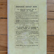
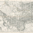
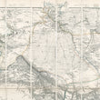
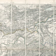
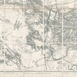
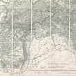
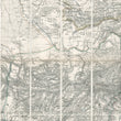
1878 Wyld’s Military Staff Map of Central Asia and Afghanistan.
DESCRIPTION
This remarkable, highly detailed large-scale map was created during a military conflict known as the Second Anglo-Afghan War, one of three such wars, each of which pitted the British Raj (Crown rule in India) against Afghanistan. The wars were fought due to the British desire to establish a buffer between themselves in India and the rapidly, ever-expanding Russian Empire. The third of these wars resulted in defeat for the British and the establishment of Afghanistan as a sovereign state.
Issued as a folding map on linen backing, the work is divided into forty sections with outline hand coloring for territorial boundaries. The map covers a broad swathe of territory starting from the Caspian Sea and Niriz, Persia (modern day Iran) at its westernmost points and extending eastward as far as Issik Kul Lake in the northeast, and Delhi in the southeast. Created specifically for military use, the map could scarcely be more highly detailed, and would have been of great value in the field.
A few details include the depiction of sites such as jade quarries, lapis lazuli deposits, and coal mines. Trails through the great desert regions are delineated, along with the location of water wells and salt pits in those areas, information which would have been invaluable to military forces. Canals and early railway systems are denoted.
Mountain ranges are depicted in hachure and all are named, with elevations for separate peaks indicated in feet, and famous mountain passes named. Toponyms are provided for settlements, villages, towns and cities, and forts and outposts are found in the map. River systems including the Indus, Jumma, Oxus, and a short section of the Ganges to the east of Delhi are all depicted.
For those interested in this part of the world, the map would make an interesting focal point on the wall of a study or personal library. It is rarely to be found on the market, with most copies being held by institutions.
CONDITION
1200 W. 35th Street #425 Chicago, IL 60609 | P: (312) 496 - 3622


