

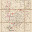

Karte des Grossherzogthums Hessen Provinz Oberhessen
DESCRIPTION
This linen-backed folding map of the Grand Duchy of Hesse Province of the Upper Hesse was created toward the end of the coalition known as the German Confederation.
The Confederation was created at the Congress of Vienna in 1815 for the purpose of managing tariffs and economic policies and consisted of more than thirty German-speaking states in central Europe. Though dissolved briefly, it was reinstated and remained a unifying force until its dissolution in 1886. This highly detailed map focuses on the province of Upper Hesse, or Oberhessen.
CONDITION
This folding map with linen backing is in A condition. An embossed royal seal is in the lower left corner.
1200 W. 35th Street #425 Chicago, IL 60609 | P: (312) 496 - 3622