

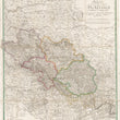
1816 Karte von Schlesien
DESCRIPTION
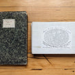
This linen-backed folding map presents a detailed view of Germany in the early 19th century. Cities, towns and settlements are named, along with separate features such as monasteries and churches. Topographical information is labeled. A legend in the lower left includes color coding for identification of the various divisions of state at the time.
Simon Schropp was a cartographer and bookseller in Berlin in the late 18th and early 19th centuries. Prussian King Frederick II was keenly aware of the need for accurate and up to date cartographic knowledge and information. He therefore granted to Schropp the right to make, publish and sell maps in Berlin. Schropp worked together with Prussian Royal Geographer Daniel Sotzmann to produce high quality maps such as this folding map which has its original cover. Despite the vicissitudes of war, occupation, etc., in Berlin over the past two centuries, the company founded by Schropp is alive and thriving in Germany today.
CONDITION
1200 W. 35th Street #425 Chicago, IL 60609 | P: (312) 496 - 3622