Our Gallery is Open | Please Contact Us To Schedule Your Visit.

Antique Topographical Map of North Zion National Monument, Utah 1938
1938 Topographical Map of the Northern Part of Zion National Monument
Load image into Gallery viewer, Antique Topographical Map of North Zion National Monument, Utah 1938
Load image into Gallery viewer, 1938 Topographical Map of the Northern Part of Zion National Monument

1938 Topographical Map of the Northern Part of Zion National Monument

Regular price $ 275.00

Unit price per 

By:  R.T.Evans, S.M.Borrell, J.J.Hayes, K.A.Bunker, P.J.Frampton, & G.B.Wooley

Date:  1938 (surveyed) / 1946

Dimensions:  36 x 32.5 inches (91.5 x 83 cm)

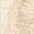
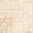
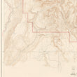
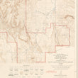
An original U.S.G.S. topographic map of the north part of Zion National Park. This section of the park features many dramatic natural landmarks and land formations including Timber Top Mountain, Death Point, Burnt Mountain and Firepit Knoll, to name a few. The varied topography is illustrated with contour lines that are numbered by elevation and the boundaries of the park are outlined in orange. The map includes a Scale for distances (miles, yards, kilometers), and a very thorough Explanation chart below, with 21 labels. Made for the United States Department of the Interior Geological Survey.

About Zion National Monument  

This beautiful National Park is in southwest Utah.  The Zion Canyon has steep red cliffs, forest trails, & the Virgin River, filled with emerald pools, waterfalls, & hanging gardens.  The park is 229 square miles and established in 1919. It attracts 4.3 million visitors per year offering various activities, such as, camping, horseback riding, wading, canyoneering, Jeep tours, lake trout fishing, visiting swim holes, and biking.

Condition:  This map is in A condition, and is professionally linen-backed for presentation and preservation purposes. The paper is pristine, with vivid color on clean paper.

Inventory: #12246

          1932 S. Halsted St.   #200  Chicago, IL  60608    P: (312) 496-3622

Close (esc)

Join Our Newsletter

Interested in maps, prints, and upcoming related events? Sign up for our newsletter for fresh NWC inventory and announcements.

Age verification

By clicking enter you are verifying that you are old enough to consume alcohol.

Search

Shopping Cart

Your cart is currently empty.
Shop now