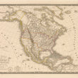

1828 Carte Generale de L’Amerique Septentrionale...
Carte Generale de L’Amerique Septentrionale, et Des Iles Qui En Dependent.
By: Adrien-Hubert Brué
Date: 1828 (Published) Paris
Dimensions: 15 x 20.25 inches (38.1 x 51.44 cm)
This large elegant map by Brué depicts the United States and its territories as they were internationally recognized in 1828. The map is of great interest as it depicts the various vast stretches of territory already claimed by the United States. In 1818, the United States and Great Britain established a join claim over the Oregon Territory, including regions north of Spanish-controlled upper California as far north as the southern boundary of Russia’s Alaskan Territory, which is called Amerique Russe.
In the 1830’s this arrangement began to be disputed, and by the 1840’s, the Democrats of America with their presidential candidate James Polk began to claim the entire region for the US. When Polk was elected, the dispute was resolved by the 1846 Treaty of Oregon, which struck a compromise that fixed the U.S./Canadian boundary at 49º North. Many territorial and state borders are depicted, and Texas is shown as part of Mexico.
An area of interest often overlooked in this map can be found in the most northern latitudes where the map depicts some of the most up-to-date cartographic information from ongoing expeditions by the British in search of a Northwest Passage. By the time this map was printed the first of many British expeditions by names like John Ross, John Barrow, William Parry, and John Franklin had begun to map the icy web of straits that makeup the northern Canadian Archipelago. This map presents a lot of new information that came as a result of those expeditions that is absent from most maps just ten years prior.
This Brué map resembles his map Carte Generale des Etats-Unis du Canada, which was based on information from the Lewis & Clark and Humbolt's expeditions, and perhaps on the work of Arrowsmith and Melish. Topography is represented in hachure. All major river systems in the continental United States are featured. The names of countless Indian tribes are included.
Adrien-Hubert Brue (1786 - 1832) was a French cartographer active in the late 18th and early 19th centuries. He held the office of Geographe du Roi and often signed his maps as such. In this position Brue contributed to thousands of maps and numerous atlases. Like most cartographers many of his maps were published posthumously for several decades after his death by his partner, Charles Picquet's son and heir, Pierre-Jacques Picquet.
Brue’s work is always distinguished by the high quality paper which he used and a remarkably high standard of engraving. This grand copper-engraved map by Brue is printed on heavy paper with wide margins, royal seal, script title and elegant keyboard border.
Condition: This map is in superb A condition. Lovely, original outline coloring and a color-coded key embellish the map.
Inventory #11603
1200 W. 35th Street #425 Chicago, IL 60609 | P: (312) 496 - 3622


