


1950 City of Detroit - Master Plan
By: City Plan Commission
Date: February 15, 1950 (dated) Detroit, MI
Dimensions: 26 x 38.5 inches (66 x 98 cm)
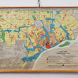
This mid-century wall map of Detroit illustrates the city's various methods of land use through a wide spectrum of color. This includes the differentiation between one and two family homes and various densities of residential dwellings, major business and general commercial districts, and light and heavy areas of industry. Major public recreation areas are noted in a darker shade of green than smaller open spaces, institutions and public buildings, but other public spaces such as playgrounds, schools and community facilities are not included in the map.
At the time of printing this map, Detroit's population had reached 1.85 million, making it America's fourth-largest city, with 296,000 manufacturing jobs. What started as a town that grew through auto manufacturing for companies like Packard, Hudson, and Studebaker had a sudden surge of jobs for manufacturing war materials for the United State's effort in WWII.
In the postwar period of the 1950s, the city had lost nearly 150,000 jobs to the suburbs. Factors were a combination of advances in technology, automation, consolidation of the auto industry, the need for different kinds of manufacturing space, and the construction of the highway system that eased transportation for commuters. This combined with social-economic factors would lead to the beginning of a long decline in wealth and living standards with an increased unemployment rate and eventually civil unrest in the city for decades to come.
Today however Detroit is on the rise again and evidence is most readily found in the Midtown Area and the Central Business District, which have attracted a number of high-profile investors. It is also being driven by the formation of public-private-nonprofit partnerships that protect and maintain Detroit's most valuable assets such as the riverfront.
Condition: This wall map is in A condition with bright colors over strong linen-backed paper. The map is on its original wood rollers that can be removed at the buyer's request for framing purposes.
Inventory #11471.
1200 W. 35th Street #425 Chicago, IL 60609 | P: (312) 496 - 3622