


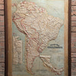


1892 / 1907 Relief Map of South America
DESCRIPTION
This is an original antique relief map of South America by the Atlas School Supply Company, constructed in 1907 out of their headquarters in Chicago, Illinois.
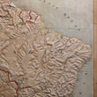
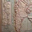
The map offers a combination of political geography, physical topography, with rivers, lakes, mountains ranges, plateaus, etc. noted throughout. Larger towns, cities, capitols, and geo-political boundaries are also provided, while roads and railways are omitted from the map. A vertical scale at lower-right notes that the height of elevations is exaggerated 45 times.
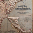
Two inset maps appear in the lower portion, one showing the Nicaragua and Panama Canal routes, and another more detailed map of the Panama Canal route from 1897. It was at the time of this maps' creation that construction of the Panama Canal was underway. It had only been a few years prior that the United States abandoned its efforts in building a Nicaragua Canal after it purchased the French interests in the Panama Canal. Construction of the Panama canal began in 1904 and would not be completed until August 15, 1914 when the SS Ancon would be the first ship to not have to circumnavigate South America to reach the Pacific from the Atlantic Ocean.
CONDITION
1200 W. 35th Street #425 Chicago, IL 60609 | P: (312) 496 - 3622