


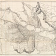


1853-55 Milk R. to the Crossing of the Columbia R.
By: Isaac Stevens
Date: 1853-55 (published) New York
Dimensions: 23.75 x 61.25 inches (60.33 x 155.6 cm)
This is a highly detailed map of the region between the Upper Missouri and the area around Fort Benton to the Columbia River, primarily covering Montana. Above the title is the following note: "Explorations and Surveys for a Rail Road Route from the Mississippi River to the Pacific Ocean. War Department. Routes near the 47th and 49th Parallels. Milk R. to the Crossing of the Columbia R."
The map shows the graphic depiction of the Pacific Railroad Surveys as its engineers surveyed for a northern route (47th and 49th Parallels) on an expedition led by Isaac Stevens, Governor of Washington Territory. The area covered starts in the east with the Yellowstone and Upper Missouri Rivers, and extends to the west well into what would become the state of Washington. Most of the map covers Idaho and Montana, with extraordinary detail and excellent relief, naming rivers, numerous expeditions and their routes, along with the names of expedition leaders and dates, and interesting topographical commentary.
This map was produced by Isaac I. Stevens under the direction of the Secretary of War, Jefferson Davis for publication in Secretary Davis’ report to Congress entitled Explorations and Surveys for a Rail Road Route from the Mississippi River to the Pacific Ocean. The map was printed by Sarony, Major and Knapp Lithographers of New York.
Condition: This three-page map was published folding and is now linen-backed. The condition is A. Separations are reinforced by the backing. Minor soiling at the edges of a few folds.
Inventory #11658
1200 W. 35th Street #425 Chicago, IL 60609 | P: (312) 496 - 3622