


1911 Map of the City of Seattle and Adjacent Territory...
By: Tucker Handford Co.
Date: 1911 (Dated) Seattle
Dimensions: 42 x 24.25 inches (106.5 x 61.5 cm)
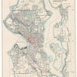
This is a scarce and eye appealing map of the the city of Seattle Washington, which includes Kirkland, Mercer Island, and Lake Washington. The map was produced to accompany the report of the Municipal Plans Commission as it details existing and proposed street and steam railways, and proposed waterfront developments and ferry routes.
Following the Klondike Gold Rush of the late 1890s, Seattle became a major transportation and shipping hub with numerous routes along the coast to Alaska and across the Pacific to Asia. In 1897 the steamer "Portland," arrived with over $1,000,000 in gold, which then earned the vessel the name "Ton of Gold Ship," and brought even more miners to the Klondike. The city did very well during this time producing clothing for miners and transporting Salmon.
In 1909, the Alaska-Yukon-Pacific Exposition brought 3,750,000 visitors to the city which was also instrumental in the progress of Seattle. During this period and the time of this map's production, Seattle shifted their economic and labor efforts into shipbuilding. The opening of the Panama Canal in 1914 hastened the city's progress as a major seaport, which became even more valuable as an industrial city during the first World War. The multitude or proposed piers and and ferry routes found within this map are a great representation of the city in the middle its evolution from a lonely port town to and industrial maritime powerhouse.
This map also provides great detail to the individual streets and neighborhoods, including Queen Anne Hill, Capitol Hill, Rainer Heights, Beacon Hill, Latona, Ballard, Ravenna, Magnolia Bluff, and West Seattle to name a few. While only major streets are names, the clear grid-like pattern, and vivid nature of the lithograph should make it easy for anyone with roots in Seattle to locate their areas of interest.
Condition: This folding map is in A condition with bright color on clean paper that has been flattened linen-backed for preservation purposes.
Inventory #11620
1200 W. 35th Street #425 Chicago, IL 60609 | P: (312) 496 - 3622