


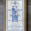

1937 Motor Map of Malaya
By: Surveyor General F.M.S. & S.S.
Date: 1937 (dated) Kuala Lumpur
Dimensions: 39 x 26.5 inches (99 x 67.25 cm)
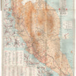
A rare folding travelers' map of Malaya showing the nation undergoing advancements to their transportation infrastructure as well as economic hardship. The map was published while Malaya was in its final years under British colonial rule, just four years prior to its occupation by Japan.
Malaya's transportation infrastructure during the 1930s can be characterized by a mix of traditional modes of transportation and the early development of modern transportation systems. This map reflects this time of transformation as it includes not only rail and motor roads but also cart tracks and bridle and foot paths. The lines delineating motor routes become dashed when in area that are liable to flood.
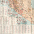
Twenty-eight inset maps offer more detail on cities and large towns throughout Malaya. These include Georgetown, Malacca, Kuala Lumpur, Penang, and Singapore to name a few. Additionally, the map provides a distance table between select cities, and four other index tables giving the locations of hospitals, rest houses, bungalows, railway stations, police stations, and post & telegraph offices among other places deemed useful for a traveler.
The map is shaded to show relief in altitude, backed with original linen, and folded securely into its original covers. handsome cover art depicts a late 1930's automobile on a dirt road beneath the towering vegetation of a tropical rainforest.
Malaya in the 1930s: Colonial Governance, Economic Shifts, and the Shadow of War
At the time of publication, Malaya was then under British colonial rule, and the British had established the Federated Malay States (Selangor, Perak, Negeri Sembilan, and Pahang) and the Unfederated Malay States (Johor, Kedah, Kelantan, and Terengganu). The British also had control over the Straits Settlements, which included Singapore, Penang, and Malacca.
The economy of Malaya was primarily based on rubber and tin mining. During the Great Depression of the 1930s the decline in commodity prices, including rubber and tin, had a significant impact on the local economy and contributed to social and political unrest. Toward the end of the 1930s, the threat of Japanese expansionism loomed over the region. Malaya would eventually be occupied by Japanese forces during World War II, marking a significant turning point in its history.
Condition: Map is in A condition with some light ware and scuffing to the covers but otherwise very nice with a secure original spine. Map is firmly bound to the cover and folds with ease.
NOTE: At the request of the buyer, this map can be removed from its book and flattened for framing. Additional fee may apply.
Inventory #12705
1200 W. 35th Street #425 Chicago, IL 60609 | P: (312) 496 - 3622