

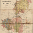
Bodenkarte vom Grossherzogthum Hessen nach R. Ludwig
DESCRIPTION
This antique German folding map of the Duchy of Hesse combines a topographical map showing cities, political divisions, transport routes and other topography, with a geologic or soil map, a geographical representation showing the composition and diversity of soil types and properties including textures and organic matter, as well as rocks, bedding planes, folds, faults, and other structural features. The map has a number of handwritten notes, including annotations marked 'baden', denoting areas where thermal springs are located.
CONDITION
Map is in very fine condition with signs of use and annotations.
1200 W. 35th Street #425 Chicago, IL 60609 | P: (312) 496 - 3622