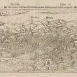

1550 De Italia Florentia nobilissima Hethruriae civitas, deformata ad nostra tempora.
By: Sebastian Münster
Date: 1550 (published) Basel
Dimensions: 8.75 x 14.25 inches (22 x 36 cm)
This fascinating map of Florence and its environs is from a Latin language edition of polymath Sebastian Münster’s Cosmographiae Universalis. Based on a fifteenth century engraving by Francesco Rosselli, the map is often called View of Florence with a Chain. This name is based on the chain depicted across the Arno, an ancient maritime means of safeguarding ports and harbors with narrow openings to the sea, and rivers or straits such as the Bosphorus which run through great cities. The map was popular in its day, one of the best-known early renderings of this remarkable Renaissance city.
The city is depicted from an elevated vantage point on the southern side of the Arno River. According to the historical chronology of architectural edifices included in the map, it is a rather accurate rendering of the city in the mid 15th century, suggesting that the Rosselli view was quite accurate, as the dome of the Duomo (Santa Maria del Fiore), which was completed in 1436, is shown as completed in Münster’s map.
The city’s great walls and watch towers are intact. Four bridges cross the Arno are at places located within the territories protected by the walls. A small vessel with two people on board is plying the river near the chain which helps protect the city from invasion. Buildings are drawn in detail, and important edifices are easily recognizable today. In one plaza four people are depicted, two seem to be watching two others engaged in a swordfight or duel. Buildings located beyond the walls include personal dwellings, churches, a belltower and what appear to be some administrative buildings on the south side of the Arno.
In addition to Santa Maria del Fiore, other major landmarks are plainly visible in the view with recognizable buildings including Santa Croce, the Baptistry of St. John, thought to have originally been the site of a pagan temple, the Campanile (bell tower) designed by Giotto, and the Ponte Vecchio, built near the site of the original Roman crossing of the river. Buildings resembling San Marco, the Basilica of San Lorenzo, and Santa Maria Novella are depicted. The map is not done to scale, and most streets and passageways are obstructed by buildings, but careful study of the map reveals the integrity of the original work. Text on the verso is in Latin.
Condition: This map is in B condition. Darker toning along upper edge and some separations in edge of the lower margin.
Inventory #12854
1200 W. 35th Street #425 Chicago, IL 60609 | P: (312) 496 - 3622


