
1682 Orbis Terrarum Tabula Recens Emendata et in Lucem Edita
By: Henrik and Jacob Keur
Date: 1682 (circa) Dordrecht
Dimensions: 14 x 18.25 inches (35.5 x 46.5 cm)
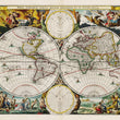
A rare example of this famous world map, published by the Keur family of the Dutch port city of Dordecht, who were renowned for their beautiful bibles. This striking double hemisphere world map featuring California as an Island is based on an earlier map by Visscher, and decorated much in the style of Visscher.
The map depicts the globe in its entirety. Both sides of the globe are flattened and connected with equatorial lines. Scattered across the ocean are numerous illustrations of ships, serving as a nod to colonial expansion and the desire for global trade.
Each corner is adorned with a scene from classical antiquity including the rape of Persephone by Hades in the upper left, and Zeus being carried across the heavens in an eagle-drawn chariot in the upper right. The lower left features a splendid vignette of Poseidon commanding his entourage, and in the lower right Demeter receives the fruits of the Earth. Cherubim fill space between the hemispheres. Astronomical diagrams at top and bottom centre represent the north and south poles.
The Latin label Polis Articus refers to the north pole. This chart shows the path of the planets and is surrounded by the zodiac symbols. In this northern chart the sun is centered with the earth, or “terra”, and the moon or “luna”, rotating around it. The south pole is labeled Polis Antaricus. In opposition to the northern chart, this depicts the Earth at the center of the universe and all other planets and our sun rotating around it.
Near Demeter in the lower right corner stands a splendid satyr alluding to Dionysus, the god of wine, festivities and theatre. In antiquity the half-man half-goat was commonly associated with fruitfulness in agriculture and animal husbandry, as well as with spiritual matters pertaining to death, afterlife, and rebirth.
As was common at the time, California is represented as an island with a flat northern coastline. The myth of California as an island is thought to have originated with the accounts of a voyage made to the region by Sebastian Vizcaino in 1602, whose scribe described the area as an island cut off from the mainland. Earlier maps correctly feature California as contiguous with the continent, including those by such eminent 16th century cartographers as Mercator and Ortelius.
The misrepresentation of it began around 1620, and continued well into the 18th century. Territory in the area is labeled with the archaic name for Britain, Nova Albion. This territory was named and claimed for England by Sir Francis Drake when he made his famous voyage there in 1579. In the open waters to the west of North America the Straits of Anian are noted, and the northwest region of the continent is named Anian Regnum, the Kingdom of Anian.
Condition: Map is in A condition with lavish coloring over a sharp impression on clean and sturdy paper. A centerfold separation well away from the image has been repaired at the bottom.
Ref: Shirley 513
Inventory #12815
1200 W. 35th Street #425 Chicago, IL 60609 | P: (312) 496 - 3622


