

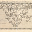

1574 Africa Nuova Tavola
By: Girolamo Ruscelli
Date: 1574 (published) Venice
Dimensions: 7.25 x 10.25 inches (18.4 x 26 cm)
This Ruscelli map is from his work La Geografia di Claudio Tolomeo Alessandrino. It is based on the work of Ptolemy and depicts the southern half of Africa, covering from 10°N latitude to 40° S latitude and the entire southern part of the continent from the Arabian Gulf in the northeast to the Del Campo River on the western coast.
The depiction of the headwaters of the Nile conforms to Ptolemaic concept, and a number of other river systems are noted. Madagascar is called Isola de S. Lorenzo and is oddly shaped. Ocean waters are stippled. Italian text on the verso, including a quote in Greek.
Girolamo Ruscelli (1500-1566) was an Italian polymath, humanist, scholar, editor, and cartographer active in Venice during the early 16th century. Ruscelli is best known for his important revision of Ptolemy's Geographia, published posthumously in 1574.
Condition: This map is in A condition. Heavily inked plated with one small spot of residue. Sharp clear impression. Italian text on the verso.
Inventory #11786
1200 W. 35th Street #425 Chicago, IL 60609 | P: (312) 496 - 3622