


1935 Idaho
By: Ruth Taylor White
Date: 1935 published Boston
Dimensions: 9.25 x 12.5 inches (23 x 31 cm)
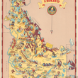
This colorful map of Idaho depicts the Rockies, where it slopes off into the Great Basin. This state is famed for producing apples, potatoes, & pine timber. This is the home of various Indian tribes, such as the Shoshones, The Nez Perce, and the Bannocks. Cattle & sheep raising, along with mining of gold, zinc, lead, & silver define certain areas. The Continental Divide and Seven Devil Mountains help to add life to this map, while clearly defining borders are indicated. The vignette of a farmer holding two giant potatoes is on the upper right side, beneath the state's name.
Note: Image of map description is not on the verso of this map.
Condition: Map is in A condition with no tears, holes, or staining.
Inventory #17157
1200 W. 35th Street #425 Chicago, IL 60609 | P: (312) 496 - 3622