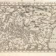

1574 Polonia et Hungaria Nuova Tavola
By: Girolamo Ruscelli
Date: 1574 (published) Venice
Dimensions: 7.25 x 10.25 inches (18.4 x 26. cm)
This Ruscelli map from his work La Geografia di Claudio Tolomeo Alessandrino, is based on the work of Ptolemy and covers all or parts of Poland, Hungary, Slovakia, the Czech Republic, Rumania, Bulgaria, Serbia, Silesia, Moldavia, Walachia and the northwestern tip of Anatolia, including Constantinople. Much of western Russia and a portion of Ukraine which is drained by the Dnepr River system are depicted. Many regions of this territory were at least under Ottoman suzerainty if not complete dominion of the Ottoman Empire under Suleiman the Great at the time the map was published, and for some time thereafter.
The region is bounded by the Black Sea and western Russia in the east and the vast Danube River system in its southern reaches. The northern reaches include the Russian city of Smolensk, Vilnius in Lithuania, and Strasburg in what was then Prussia. The Transylvanian Alps are shown in great detail, various tree species are represented in forested areas and large lakes and river systems are presented in detail. Major cities and regions are denoted and named.
Girolamo Ruscelli (1500-1566) was an Italian academic, polymath, humanist, scholar, editor, and cartographer active in Venice during the early 16th century. Ruscelli is best known for his important revision of Ptolemy's Geographia, published posthumously in 1574.
Condition: This map is in A condition. Heavily inked plated with some minimal residue, otherwise sharp clear impression. Italian text on the verso.
Inventory #11791
1200 W. 35th Street #425 Chicago, IL 60609 | P: (312) 496 - 3622


