


Nuevo mapa de la República oriental del Uruguay
By: Joseph Forest
Date: Late 19th Century - Paris
Dimensions: 48 x 37 inches (122 x 94 cm)
This is a scarce wall map of the Oriental Republic of Uruguay that was produced for schools in the late 19th century by Joseph Forest out of Paris, France. The country was commonly referred to the Orient because of its position east of the Uruguay River.
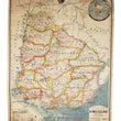
The map is color coded by department (region or state) with an emphasis given to physical topography, and delineation of rivers and railways (constructed, under construction, and proposed). Numerous lighthouses are noted along the coast with circular red lines indicating the average distance to which they can be seen by passing ships. Other red lines show submarine communication cables and shipping routes. The map also notes the primary exports of Uruguay that are primarily based in agriculture and livestock, including wool, animal hides and skins, frozen meat, timber and other forestry products.
In the top right, an inset map titled "La Republica del Uruguay en el Mundo," presents a map of South America centered on the Tropic of Capricorn and 60 degrees west longitude, noting Uruguay in red shading. The map is adorned at the top with the official Coat-of-Arms of Uruguay, which is best described by World Atlas below.
- The Coat of Arms consists of an oval, divided into four equal sections and crowned by a rising golden sun, the "Sun of May", symbolizing the rising of Uruguay. The oval is surrounded by a laurel branch on the left and an olive one on the right, representing honor and peace.
In the upper left quadrant, there is a scale, representing equality. The upper right quadrant contains the Cerro de Montevideo (Montevideo Hill) with its fortress on the summit, representing strength. In the lower left quadrant, there is a galloping horse, representing liberty. The lower right quadrant shows an ox, representing abundance.
This map was produced by Joseph Forest, who in 1886 founded a publishing house of maps and plans, worlds, globes, terrestrial and celestial spheres , paintings and wall maps for education at 17-19, rue de Buci in Paris. This map bears the same address which helps us date it to the late 19th century as Joseph Forest made a career change in the early 20th century to the import / export business.
Condition: This map is in B+ condition with a minor paper pull and some light discoloration in the top portion. It is on its original rollers that can be removed upon the request of the buyer for framing.
Inventory #11579
1200 W. 35th Street #425 Chicago, IL 60609 | P: (312) 496 - 3622