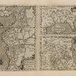

1592 Peruviae Auriferae Regionis Typus, La Florida, Guastecan Reg.
DESCRIPTION
This important work from Ortelius’ atlas Theatrum Orbis Terrarum features maps which were among the very few to be based on Spanish sources, all of which draw from the expedition of Hernando de Soto through the region. The sheet includes three maps, one of which is the La Florida, the first printed map of the southeastern portion of the United States. The map became influential due to its detailed depiction of the river system.
Below Florida is a map entitled Guastecan Reg., which combines with La Florida to extend the coastline of the Gulf of Mexico farther south. The third map features Peru, where De Soto was the first European to meet Incan Emperor Atahuallpa. In the north of the map of Peru Ortelius indicated the Aurea Regio, or Kingdom of Gold, in reference to the fabled El Dorado.
Each map is embellished by a decorative cartouche and the map of Peru features two ships at sea. Descriptive text on the verso is in Spanish.
CONDITION
1200 W. 35th Street #425 Chicago, IL 60609 | P: (312) 496 - 3622


