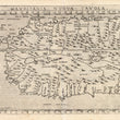

1574 Mauritania Nuova Tavola
By: Girolamo Ruscelli
Date: 1574 (published) Venice
Dimensions: 7.25 x 10.25 inches (18.4 x 26 cm) plate size
This Ruscelli map from his work La Geografia di Claudio Tolomeo Alessandrino, is based on the work of Ptolemy and covers the northwest portion of the African continent, from the Mediterranean to the long coast to the south which Ruscelli has depicted as almost parallel to the northern coast. Numerous islands in the Atlantic are also denoted. Ruscelli shows many rivers, enlarged lakes, numerous mountain ranges, and stippled sea and ocean waters. This is one of the earliest printed maps of the region.
Mauritania is a mainly desert country spanning the Arab Maghreb of North Africa and the western sub-Saharan Africa. The country today has a population of 3.1 million, divided between the Arab-Berber population to the north and Africans to the south. In the Middle Ages, Mauritania was the cradle of the powerful Almoravid dynasty, which spread Islam across North Africa and later controlled Islamic Spain.
Girolamo Ruscelli (1500-1566) was an Italian polymath, humanist, scholar, editor, and cartographer active in Venice during the early 16th century. Ruscelli is best known for his important revision of Ptolemy's Geographia, published posthumously in 1574.
Condition: This map is in B+ condition. Heavily inked plated with some residue, some faded areas of lettering, otherwise sharp impression. Italian text on the verso.
Inventory #11785
1200 W. 35th Street #425 Chicago, IL 60609 | P: (312) 496 - 3622


