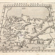

1574 Tabula Asiae I
By: Girolamo Ruscelli
Date: 1574 (published) Venice
Dimensions: 7.25 x 10.25 inches (18.44 x 25.9 cm)
This fascinating Ruscelli map is from his work La Geografia di Claudio Tolomeo Alessandrino. Ruscelli based much of his work on that of Claudius Ptolemy, and on the atlas maps of Giacomo Gastaldi.
This trapezoidal map focuses on Asia Minor, depicting Anatolia in full plus a bit of Georgia and Armenia, a portion of eastern Europe on the Black Sea, Cypress, Crete and a number of other smaller island of both the Aegean and Mediterranean Seas. Ruscelli uses names from antiquity to identify places and regions, some which have changed and others which are still close enough to the original to be identifiable.
Girolamo Ruscelli (1500-1566) was an Italian cartographer, polymath, humanist and editor, active in Venice during the early 16th century. Ruscelli is best known for his important revision of Ptolemy's Geographia, published posthumously in 1574.
Claudius Ptolemy (85-165 CE), a Roman citizen of Greek descent from Alexandria, was the most influential of Greek astronomers and geographers of his time. He propounded the geocentric theory of the solar system which was to prevail for the next 1400 years.
Giacomo Gastaldi (c.1500-1566) was an Italian astronomer, cartographer and engineer from Villafranca in Piedmont. Many of Ruscelli’s maps are essentially enlarged versions of some of Gastaldi’s maps.
Condition: This map is in A condition. It is slightly over-inked as is often seen in the first few copies of a new edition, especially on new plates, which were created for this 1574 posthumous edition of Ruscelli’s Atlas.
Inventory #11873
1200 W. 35th Street #425 Chicago, IL 60609 | P: (312) 496 - 3622


