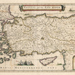

1636 Natolia, quae olim Asia Minor.
By: Jan Jansson
Date: 1636 (circa) Amsterdam
Dimensions: 15 x 19.75 inches (38.1 x 50.2 cm)
This map of Asia Minor by Jan Jansson was published in Amsterdam circa 1636.
The territory covered extends from the Euphrates River to Thrace and the Aegean Islands, and from the Black Sea to the Mediterranean. Included in the map are the islands of Cyprus, Crete, Rhodes and cities such as Antioch, Troy, Constantinople and Smyrna (modern Izmir). The region has been home to countless civilizations throughout history from the ancient Paleolithic Era, and some of the earliest known permanent settlements have been found in Anatollia. Empires dating to myriad eras have grown and declined in the region including ancient Greek, Roman, Byzantine and Ottoman, to name a few.
Following the conquest of Constantinople by Fatih Mehmet in 1453, the Ottoman Empire increased its power and domain, reaching its apex under the rule of Suleyman the Magnificent in the sixteenth century, when the Empire was one of the most powerful states in the world. At its height the Ottoman Empire included most of southeastern Europe, as far as the gates of Vienna. It included present-day Hungary, the Balkans and Greece and parts of modern-day Ukraine. Egypt and much of North Africa including Algeria were controlled by the Ottomans, as was the Arabian Peninsula. In the Middle East it included portions of regions now occupied by Syria, Iraq, Israel and Iran.
The map appears to be based on the 1634 Blaeu map of the same territories. It was published almost two hundred years after the conquest of Byzantium, when the decline of the Ottoman Empire was already underway. Over the centuries the power of the Empire would increasingly decline until finally being replaced in the 20th century when Ataturk led the movement that resulted in the founding of the Turkish Republic..
Embellishment includes a title cartouche with two cherubs, vignettes of ships at full sail on the sea, a battle at sea, and some friendly sea monsters. A distance scale showing German miles is in the lower right corner of the map.
Condition: Map is in B condition with a fine impression, lovely color and full margins. Some offsetting is apparent as a result of the original coloring. A centerfold separation at the bottom has been repaired on the verso.
Inventory #12595
1200 W. 35th Street #425 Chicago, IL 60609 | P: (312) 496 - 3622


