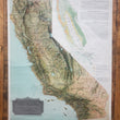


1899 Weber's Relief Map of the State of California Showing Forestry Districts
By: H.S. Crocker Company
Date: 1899 (circa) San Francisco, CA
Dimensions: 41 x 28 inches (122 x 71 cm)
A rare relief wall map California showing the forestry districts and the types of timber found throughout the state. Printed with English, French, and German text, this map was originally published for the 1900 Paris World's Fair, Exposition Universelle.
The larger map presents California in shaded relief, illustrating the wide range of topography from the high Sierra Nevada Mountains to the low lying desert valleys in the southeast portion of the state. Counties are outlined in red, and railroads are delineated in black black with all stations noted along the way. Lakes both wet and dry are also noted, including Tulare Lake as it was prior to being drained for agricultural purposes in the lower central valley.
A smaller map which occupies the region of what would be Nevada shows the state color coded by the variety of timber resources. These include Sequoia Gigantea (Big Trees) in pink, Sequois Semperuirens (Redwood) in orange, Pines and other Conifers in light green, scattered Oaks and Digger Pine in yellow, and Large body Commercial Timber in dark green. Three large bodies of text (in English, French, and German) describe in detail the composition of two large bodies of valuable timber, the Redwood Belt, and the Sierra Forest Belt.
There are only two known other institutional examples of this map and there exists a variant lacking the silver title cartouche that recognizes the California-Paris Exposition Commission, with the names of the commissioners and the secretary. Curiously, upon close examination of the title cartouche, we find the faint imprint of Crocker's name beneath the name of Weber.
Condition: This map is in A condition, still securely fastened to original wood rollers and laid on original linen. Colors are vibrant and paper is brighter (less yellow) than it appears in our image.
Inventory #12535
1200 W. 35th Street #425 Chicago, IL 60609 | P: (312) 496 - 3622


