

1851 Die Vereinigten Staaten von Nord-Amerika
By: Dr. F.W. Streit
Date: 1851 (dated) Leipzig, Germany
Dimensions: 15.5 x 18.75 inches (39.5 x 47.5 cm)
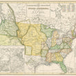
This is a late and rare edition of Dr. Streit's interesting and unusual map of the United States. Dr. F.W. Streit was a mathematician, cartographer, and engineer in the Prussian artillery. The map presents much of the continental United States, omitting the Southwest and instead, providing four inset maps of Washington D.C., New York, Boston, and Philadelphia to Trenton.
While the map is dated 1851, it doesn't seem to have been properly updated. Though the map post-dates the Mexican-American War and Texas joining the Union, what little it shows of the southwest better reflects the region while still under Mexican control. Texas is depicted with border similar to those found on maps in the late 1830s and is not listed as part of the United States in the key at top right.
In the east, each state is clearly presented in a contrasting color, corresponding with the key provided. The trans-Mississippi West is shows to mostly consist of the unorganized Missouri Territory that would change in three years with the passing of the Kansas-Nebraska act. The Oregon Territory is accurately shown as part of the United States, without the extension into British Columbia that we find in other maps of the era.
In the district of California, Dr. Streit depicts many rivers, some topography, and the locations of Native American Tribes. Interestingly, Streit also shows two versions of the fictitious "River of the West," that was debunked by the Fremont Expedition in the decade prior. One, the Timbango flows from Timbagos Sea to San Francisco Bay, and further south, the Bonaventura flows from the Tegijo Sea to somewhere along California's central coast.
Condition: Map is in A+ condition with bright original color on clean paper presenting ample margins on all sides and no tears, holes, or stains.
Inventory #12351
1200 W. 35th Street #425 Chicago, IL 60609 | P: (312) 496 - 3622


