


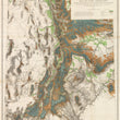


1878 Map of Utah Territory Representing the Extent of the Irrigable, Timber and Pasture Lands
By: Charles Mahon, J.H. Renshawe, W.H. Graves, H. Lindenkohl
Date: 1878 (published) New York, Julius Bien lithographer
Dimensions: 36.25 x 28.75 inches (92.08 x 73.03 cm)
This splendid highly detailed map of the Utah Territory was drawn and published almost twenty years before Utah became a state. It was an achievement of incalculable value as it demonstrates in detail the vast natural resources of the state. The map resulted from a U.S. Geographical and Geological survey of the Rocky Mountain region, headed by J.S. Powell.
The map notes all settlements, towns and cities. Wagon roads, trails, rail roads, telegraph lines are delineated. Those areas of irrigable land, standing timber, and pasture lands are coloured according to the colour-coded legend. All major geographical and topographical features are shown with relief shown by hachures.
A note on the map states the following: "This map has been constructed from atlas sheets of the U.S. Geographical and Geological Survey of the Rocky Mountain region with additional material taken from the maps of the U.S. Geographical Explorations and surveys west of the 100th meridian, Lieut. Geo. M. Wheeler, Corps of Engineers, in charge ; the U.S. Geological Exploration of the 40th parallel, Clarence King, U.S. Geologist in charge ; and the U.S. Geologial and Geographical Survey of the Territories, F.V. Hayden, in charge."
Julius Bien (1826-1909) was an American lithographic printer and cartographer who worked in New York City in the second half of the 19th century. He was responsible for the publication of thousands of maps issued by the U.S. government and private map publishers. He was a pioneer in the development of chromolithography. He is recognized as one of the finest map printers of his time. Although authorship of 19th century maps and atlases is never limited to one person, and most of these cartographic productions list authors other than Bien, he had a major role in shaping the final results. Bien's printing and publishing of geological maps was outstanding and he took geological visualizations to new levels, as can be seen in this fine map of the Utah Territory.
Condition: This map is in excellent condition. It was issued folding and is now linen-backed. Slight separations and one small area of light soiling. The image is bright with original colouring.
Inventory #11656
1200 W. 35th St. #425 Chicago, IL 60609 | P: (312) 496 - 3622