


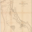


1878 Map of the Upper Geyser Basin Yellowstone National Park
By: Ferdinand V Hayden
Date: 1878 (dated) Washington D.C.
Dimensions: 24 x 34.75 inches (60 x 88.25 cm)
This is a scarce and early map of the interior of Yellowstone National Park focusing on the Upper Geyser Basin, which is home to the Old Faithful Geyser Group.
This map follows Firehole River south from its fork with Iron Sprink Creek, near the "Soda Geyser Group," all the way to the famed Old Faithful Geyser Group. This stretch of the park is some is home to some of the most geothermally active geysers, which were the inspiration for protecting the area as a environmental refuge. The geyser groups depicted in the map include "Grotto," "White Pyramid," "Grand," "Castle," and Giantess," to name a few.
Ferdinand Hayden, known to the Sioux as "man-who-picks-up- stones-running" was one of the most important geologists of the 19th Century. From the 1853 - 1878 he provided the United States government and land speculators with vital information pertaining to the American West as was an instrumental figure in the founding of the world's first national park, Yellowstone. While Hayden first entered the Yellowstone region in 1871, it wasn't until 1878 that he felt his work was complete. It was the later surveys which this map was drawn upon.
Condition: This map is in B condition with prior tape removed and fold separations closed. Minor areas of paper loss have been filled. The map is backed with linen to reinforce the thin and fragile paper it was printed on.
Inventory #11856
1200 W. 35th Street #425 Chicago, IL 60609 | P: (312) 496 - 3622