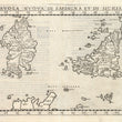

1574 Tavola Nuova Di Sardigna Et Di Sicilia
By: Girolamo Ruscelli
Date: 1574 (published) Venice
Dimensions: 7.4 x 10.4 inches (18.8 x 26.42 cm) plate size
This map is one of the earliest obtainable modern era maps of the region. It depicts Sicily, Sardinia and Malta along with a portion of the western coast of Italy and numerous smaller islands.
This highly desirable Ruscelli map is from his work La Geografia di Claudio Tolomeo Alessandrino. Ruscelli based much of his work on that of Claudius Ptolemy and the atlas of Giacomo Gastaldi.
The map is minutely detailed, and includes cities, towns and ports. An erupting Mount Etna on Sicily is pictorially represented, forested areas are clearly delineated, and what appears to be a wild mountain goat is featured in Sardinia. Mountain ranges and river systems are clearly defined.
Girolamo Ruscelli (1500-1566) was an Italian cartographer, polymath, humanist and editor, active in Venice during the early 16th century. Ruscelli is best known for his important revision of Ptolemy's Geographia, published posthumously in 1574.
Claudius Ptolemy (85-165 CE), a Roman citizen of Greek descent from Alexandria, was the most influential of Greek astronomers and geographers of his time. He propounded the geocentric theory of the solar system which was to prevail for the next 1400 years.
Giacomo Gastaldi (c.1500-1566) was an Italian astronomer, cartographer and engineer from Villafranca in Piedmont. Many of Ruscelli’s maps are essentially enlarged versions of some of Gastaldi’s maps.
Condition: This map is in A condition. Well-inked, crisp impression. Italian text on the verso.
Inventory #11804
1200 W. 35th Street #425 Chicago, IL 60609 | P: (312) 496 - 3622


