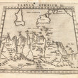

1574 Tabula Africae II
By: Girolamo Ruscelli
Date: 1574 (published) Venice
Dimensions: 7.5 x 10.25 inches (19 x 26.04 cm)
This Ruscelli map in trapezoid form is from his work La Geografia di Claudio Tolomeo Alessandrino. Based on the work of Ptolemy this map of central northern Africa depicts portions of Algeria, Tunisia, and Libya. The Mediterranean includes many small offshore islands near the coast of Africa, all of which are named, in addition to the islands of Sicily and Sardinia. The toe and heel of the ‘Boot of Italy’ are depicted, as is the western edge of what is now Albania.
Northern Africa includes much topographic information, including cities and towns, ports, rivers, mountain ranges and deserts in the vicinity. The seas, which include the Mediterranean, Adriatic, and Tyrrhenian, are all stippled. There is descriptive text in Italian on the verso.
Girolamo Ruscelli (1500-1566) was an Italian polymath, humanist, editor, and cartographer active in Venice during the early 16th century. Ruscelli is best known for his important revision of Ptolemy's Geographia, published posthumously in 1574.
Condition: This map is in A condition. The impression is crisp and dark aside from a small portion in the lower right which appears slightly smudged.
Inventory #11782
1200 W. 35th Street #425 Chicago, IL 60609 | P: (312) 496 - 3622


