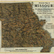

1933 Pictorial Map of Missouri...
Pictorial Map of Missouri Showing State Highway System, State Parks, Streams, and County Seats | A Century of Progress Issue Commemorating The 1933 Chicago Exposition
By: Missouri State and Highway Commission
Date: 1933 (dated) Jefferson City, MO
Dimensions: 19 x 27 inches (48.25 x 68.5 cm)
This is an eye-appealing map of Missouri, the "Show Me State," that was based upon and original painting by Arthur P. Moody, was issued for the 1933 Century of Exposition in Chicago, IL. The map pulls at the viewer in an effort to draw them to Missouri for travel and / or settlement.
Cities are shown in a birds-eye pictorial fashion with detail given to specific buildings. Farms and natural features such as forests, rivers and lakes fill in the spaces between the system of highways that intertwine throughout the state. Descriptive text and colorless photographs of the state's many attractions surround the map and appear on verso. Additionally, members of the Missouri State Highway Commission and Elective Officials are listed within the right portion of the map where Illinois would reside.
Condition: Map is in B condition with some fold separations that have been reinforced on the verso using archival materials.
Inventory #11663
1200 W. 35th Street #425 Chicago, IL 60609 | P: (312) 496 - 3622


