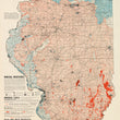


1955 Mineral Industries of Illinois
By: Educational Extension Division
Date: January 1, 1955 (dated) Illinois
Dimensions: 48 x 28 inches (122 x 71 cm)
A fascinating, mid-century, large map of Illinois presenting all facets of its mineral industries in splendid form. The map was produced by the Educational Extension division under the department of the State Geological Survey for the use of industries, well drillers, land owners, schools, and the general public.
The map is color-coded and labeled throughout, displaying a wealth of information in a very clean and easy-to-use format. Subject matter show and described within the map include mineral industries, mineral fuels, rock and rock products, sand and gravel, clay and clay products, groundwater, fluorspar and metals. County lines, towns, and railroad lines shown, but clearly not the central focus of the map.
Condition: Map is in A condition, backed with linen of preservation and presentation purposes.
Inventory #11687
1200 W. 35th Street #425 Chicago, IL 60609 | P: (312) 496 - 3622


