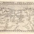

1574 Marmarica Nuova Tavola
By: Girolamo Ruscelli
Date: 1574 (published) Venice
Dimensions: 7.25 x 10.25 inches (18.4 x 26 cm)
This Ruscelli map from his work La Geografia di Claudio Tolomeo Alessandrino, is based on the work of Ptolemy and covers a portion of northern Africa from the Arabian Peninsula in the east to Cyrene in the west, an ancient city in northern Africa which was founded as a Dorian colony in the seventh century B.C., in what is now the country of Libya. The map depicts cities, river systems and lakes, mountain ranges, and portions of both the Red Sea and the Mediterranean.
At the time this map was first drawn, the region was part of the Ottoman Empire under Suleiman the Magnificent, known to the Ottomans as the Lawgiver, under whose reign Libya fell in 1551. Indeed, much of the northern portion of Africa which is featured here was controlled by the Ottomans for some time. Under Suleiman the Ottomans developed a great naval force which was headed by the famed Barbarossa, who built it to such an extent that there were more ships in the Ottoman fleet than in all the fleets of Western Europe combined. By the mid 16th century, the Ottomans were the dominant force in much of Europe, the Middle East, northern Africa and in the east of the continent as far south as the Horn of Africa.
Girolamo Ruscelli (1500-1566) was an Italian academic, polymath, humanist, scholar, editor, and cartographer active in Venice during the early 16th century. Ruscelli is best known for his important revision of Ptolemy's Geographia, published posthumously in 1574.
Condition: This map is in A condition. Heavily inked plated with some residue, otherwise sharp clear impression. Italian text on the verso. Centerfold separation in the lower edge has been repaired with archival material on the verso.
Inventory #11788
1200 W. 35th Street #425 Chicago, IL 60609 | P: (312) 496 - 3622


