


1626 The Turkish Empire
By: John Speed
Date: 1626 (Published) London
Dimensions: 15.5 x 20 inches (39.4 x 50.8 cm)
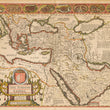
This map, which was originally published in 1626, depicts the territories of what Speed called the Turkish Empire in the early years of the 17th century. The map includes Italy in the northwest, Russian in the north, Tartaria, Persia and Arabia to the east and the northeast corner of Africa, much of which was controlled by the Ottomans at the time. On the verso in English is a comprehensive (for that time) description of the Ottomans, their origins, their history, traditions and religion.
The so-called Turkish Empire, which was in fact the Ottoman Empire, was one of the mightiest and longest-lasting dynasties in world history. This superpower ruled large areas of the Middle East, Eastern Europe and North Africa for more than 600 years. The head of state was a Sultan who had absolute religious and political authority over his people. Western Europeans generally viewed them as a threat, but many historians regard the Ottoman Empire as a source of great regional stability and security, and of important achievements in the arts, science, religion and culture as well. The Ottomans allowed freedom of worship in occupied territories, and in general governed with a loose rein so long as taxes were paid when due.
This fascinating map includes interesting commentary regarding the various peoples of the regions depicted. For example, reference is made to Prester John, the legendary Nestorian-Christian emperor or king-priest who, according to various reports, was supposed to have ruled in the far east beyond Persia and Armenia. Speed places him in Abyssinia. Eight major cities including Alexandria, Constantinople and Jerusalem are depicted in vignettes along the top of the map, and running down either side are vignettes portraying husbands and wives of different peoples, including Greeks, Egyptians, Assyrians, Arabians and Persians clothed in native raiment. Text inside a small cartouche states that the map is available in Fleet Street and in St. Paul’s Churchyard in London.
Condition: This map is in very fine condition on slightly brittle paper with some chips at some edges. Centerfold separations at the top and bottom have been repaired with archival material on the verso. Color appears to be old, but not original.
Inventory #11558
1200 W. 35th St. #425 Chicago, IL 60609 | P: (312) 496 - 3622