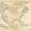

19th Century Facsimile : The North Part of America... by Briggs, 1625
By: Henry Briggs / Unknown
Date: 1625 / Early - Mid 19th Century
Dimensions: 11 x 14 inches (28 x 35.5 cm)
This is an unrecorded facsimile of the Briggs map of the North Part of America. It was printed using lithograph technology on old, watermarked paper and has the following annotation on the verso.
"Gekauft bey Butsch siehe Catalog XXVII v. [vom] Mai 1853," which translates to "Bought at Butsch see catalog twenty-seven of May 1853."
The Briggs map was the first map of North America to show California as an Island, among several other cartographic first with regards to nomenclature. It was the first map to name Hudson Strait, Bay, and River, Cape Cod, San Diego and Monterey. The map also notes the early settlements of Plymouth and James Citti, and continues to reinforce regional names from earlier maps, such as New England, Virginia, and Florida.
The opriginal Briggs map was included in Samuel Purchas’ voyage collection, "Hakluytus Posthumus, or Purchas his Pilgrimes," which is highly regarded as one of the more famous books on exploration to be published in the English language. The map was highly influential with regards to promoting the myth of California as an Island as well as the potential for a Northwest Passage.
Condition: Map is in B condition with some holes along the centerfold where the map was at some point removed from a book or folio atlas, the origins of which are unknown.
Inventory #11546
1200 W. 35th Street #425 Chicago, IL 60609 | P: (312) 496 - 3622


